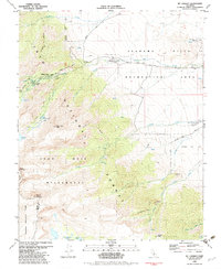
1982 Map of Mt. Langley
USGS Topo · Published 1983About this map
Inyo National Forest and the John Muir Wilderness dominate this 1982 survey, capturing the dramatic elevation change from the valley floor to the high sierra. The map highlights the essential infrastructure for access to the high peaks, including Whitney Portal Road and the established Whitney Portal Campground and Whitney Portal Picnic Area. To the east, the distinct geological formations of the Alabama Hills and Movie Flat are documented within the Alabama Hills Recreation Area, illustrating the region's long-standing importance for both recreation and the film industry. High-altitude hydrology is meticulously charted, from the Cottonwood Lakes and Muir Lake in the south to the glacier-carved Meysan Lake and Lone Pine Lake tucked beneath the granite faces of Mount Langley and Lone Pine Peak.
Find a feature on this map
38 named features on this map. Tap any name to fly to it.
Don’t see what you’re looking for? This feature index may not catch every label — zoom into the map to look around manually.
Map Details
Editions of this 1982 Mt. Langley Map
This is the sole edition of this map. No revisions or reprints were ever made.
Other maps of this area

1905 · Olancha
USGS Topo · 1:125,000

1907 · Olancha
USGS Topo · 1:125,000

1907 · Mt. Whitney
USGS Topo · 1:125,000

1919 · Mt. Whitney
USGS Topo · 1:125,000

1937 · Mt. Whitney
USGS Topo · 1:125,000

1948 · Fresno
USGS Topo · 1:250,000

1955 · Fresno
USGS Topo · 1:250,000

1956 · Fresno
USGS Topo · 1:250,000

1956 · Mount Whitney
USGS Topo · 1:62,500

1956 · Olancha
USGS Topo · 1:62,500