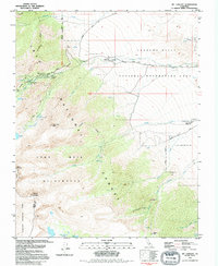
1993 Map of Mt. Langley
USGS Topo · Published 1994About this map
Mount Langley and Lone Pine Peak dominate the western portion of this terrain, marking a dramatic rise from the desert floor into the high Sierra. The landscape is defined by its recreation and conservation history, showing the intersection of Inyo National Forest, Sequoia National Park, and the John Muir Wilderness. To the east, the geological transition into the Alabama Hills and Movie Flat provides a distinct contrast to the high peaks. The map reveals a network of alpine hydrology, including Cottonwood Lakes, Muir Lake, and Meysan Lake, which feed the drainages of Tuttle Creek and Lone Pine Creek. Human activity is concentrated along corridors like Whitney Portal Road, providing access to high-altitude landmarks such as the Whitney Portal Campground and the Whitney Portal Picnic Area.
Find a feature on this map
39 named features on this map. Tap any name to fly to it.
Don’t see what you’re looking for? This feature index may not catch every label — zoom into the map to look around manually.
Map Details
Editions of this 1993 Mt. Langley Map
This is the sole edition of this map. No revisions or reprints were ever made.
Other maps of this area

1905 · Olancha
USGS Topo · 1:125,000

1907 · Olancha
USGS Topo · 1:125,000

1907 · Mt. Whitney
USGS Topo · 1:125,000

1919 · Mt. Whitney
USGS Topo · 1:125,000

1937 · Mt. Whitney
USGS Topo · 1:125,000

1948 · Fresno
USGS Topo · 1:250,000

1955 · Fresno
USGS Topo · 1:250,000

1956 · Fresno
USGS Topo · 1:250,000

1956 · Mount Whitney
USGS Topo · 1:62,500

1956 · Olancha
USGS Topo · 1:62,500