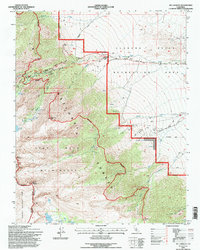
1994 Map of Mt. Langley
USGS Topo · Published 1997About this map
Lone Pine sits at the gateway to the high Sierra, where the arid floor of the Owens Valley meets the dramatic rise of the eastern scarp. This 1994 revision, based on photography from the late 1970s and early 1990s, documents a landscape defined by the intersection of commercial film history and protected wilderness. To the west, the boundary of Sequoia National Park and the John Muir Wilderness protects massive granite peaks like Mount Langley and Mount Carcoran. In the transition zone, the Alabama Hills and Alabama Hills Recreation Area are crisscrossed by tracks like Movie Road, reflecting the region's long-standing use as a cinematic backdrop. High-altitude glacial features, including Meysan Lake and Cottonwood Lakes, drain eastward through canyons carved by Tuttle Creek and Lone Pine Creek toward the valley floor.
Find a feature on this map
49 named features on this map. Tap any name to fly to it.
Don’t see what you’re looking for? This feature index may not catch every label — zoom into the map to look around manually.
Map Details
Editions of this 1994 Mt. Langley Map
This is the sole edition of this map. No revisions or reprints were ever made.
Other maps of this area

1905 · Olancha
USGS Topo · 1:125,000

1907 · Olancha
USGS Topo · 1:125,000

1907 · Mt. Whitney
USGS Topo · 1:125,000

1919 · Mt. Whitney
USGS Topo · 1:125,000

1937 · Mt. Whitney
USGS Topo · 1:125,000

1948 · Fresno
USGS Topo · 1:250,000

1955 · Fresno
USGS Topo · 1:250,000

1956 · Fresno
USGS Topo · 1:250,000

1956 · Mount Whitney
USGS Topo · 1:62,500

1956 · Olancha
USGS Topo · 1:62,500