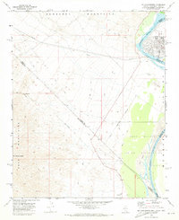
1970 Map of Mt. Manchester
USGS Topo · Published 1973About this map
The Colorado River serves as the primary boundary in this desert landscape, where the borders of Nevada, California, and Arizona converge. The river's edge is defined by the Fort Mojave Indian Reservation and the small settlement of Riviera. To the west, the arid terrain rises sharply into the Newberry Mountains and Dead Mountains, separated by a valley floor featuring significant Sand Dunes.
Find a feature on this map
22 named features on this map. Tap any name to fly to it.
Don’t see what you’re looking for? This feature index may not catch every label — zoom into the map to look around manually.
Map Details
Editions of this 1970 Mt. Manchester Map
Other maps of this area

1886 · Camp Mohave
USGS Topo · 1:250,000

1892 · Camp Mohave
USGS Topo · 1:250,000

1903 · Needles
USGS Topo · 1:125,000

1904 · Needles Special
USGS Topo · 1:125,000

1926 · Mohave City
USGS Topo · 1:96,000

1942 · Camp Mohave
USGS Topo · 1:250,000

1943 · Bannock
USGS Topo · 1:62,500

1947 · Kingman
USGS Topo · 1:250,000

1948 · Kingman
USGS Topo · 1:250,000

1950 · Davis Dam
USGS Topo · 1:62,500