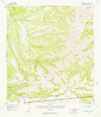
1952 Map of Mt. McKinley C-2
USGS Topo · Published 1958About this map
Kantishna and the rugged mining claims of the Kantishna Hills define this mid-century topographic record. The map reveals a remote landscape of active resource extraction, where numerous Placer Mines dot the drainages of Caribou Creek and Glacier Creek. Small outposts like Camp Denali and several scattered Cabins provide the only human settlements amidst the high peaks of Kankone Peak and Wickersham Dome.
Find a feature on this map
63 named features on this map. Tap any name to fly to it.
Don’t see what you’re looking for? This feature index may not catch every label — zoom into the map to look around manually.
Map Details
Editions of this 1952 Mt. McKinley C-2 Map
2 editions found
Other maps of this area

1951 · Mount McKinley D-1
USGS Topo · 1:63,360

1952 · Mount McKinley
USGS Topo · 1:250,000

1952 · Mount McKinley B-2
USGS Topo · 1:63,360

1952 · Mount McKinley C-3
USGS Topo · 1:63,360

1952 · Mount McKinley B-1
USGS Topo · 1:63,360

1952 · Mount McKinley C-1
USGS Topo · 1:63,360

1952 · Mount McKinley C-2
USGS Topo · 1:63,360

1952 · Mount McKinley D-3
USGS Topo · 1:63,360

1953 · Mount McKinley B-3
USGS Topo · 1:63,360

1954 · Mount McKinley D-2
USGS Topo · 1:63,360