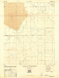
1947 Map of Mt. Mesa
USGS Topo · Published 1947About this map
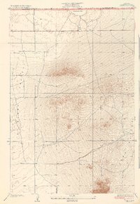
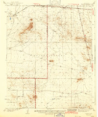
Rogers Lake dominates the northwest corner of this 1947 survey, its expansive dry bed serving as a natural foundation for the Muroc Army Airfield Military Reservation. This landscape is a stark portrait of the High Mojave Desert just after World War II, showing a transition from open desert to intensive military use. The map captures several isolated human markers, including a Lookout Tower in the northeast and unnamed Ruins near the summit of Mt. Mesa. The network of unimproved dirt roads and trails suggests a period when the area was still being surveyed and secured for aerospace testing. The terrain is marked by significant elevation changes, rising from the flat lakebed toward the prominent peaks in the south, providing a clear record of the area's geography before the extensive infrastructure of the modern Edwards Air Force Base era.
Find a feature on this map
10 named features on this map. Tap any name to fly to it.
Don’t see what you’re looking for? This feature index may not catch every label — zoom into the map to look around manually.
Map Details
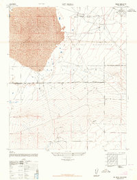
Editions of this 1947 Mt. Mesa Map
2 editions found
Other maps of this area
1930 · Joshua
USGS Topo · 1:24,000
1931 · Hi Vista
USGS Topo · 1:24,000
1934 · Joshua
USGS Topo · 1:24,000
1935 · Hi Vista
USGS Topo · 1:24,000
1937 · Shadow Mountains
USGS Topo · 1:48,000

1937 · Kramer
USGS Topo · 1:48,000
1937 · Rogers Lake
USGS Topo · 1:48,000
1942 · Kramer
USGS Topo · 1:62,500
1942 · Shadow Mountains
USGS Topo · 1:62,500
1942 · Rogers Lake
USGS Topo · 1:62,500