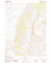
1990 Map of Mt. Moses
USGS Topo · Published 1990About this map
Mt Moses stands as the central landmark of this landscape within the Fish Creek Mountains, a region defined by complex drainage systems and evidence of historical prospecting. To the west, Jersey Valley transitions into the upland canyons, while the boundary between Pershing Co and Lander Co cuts directly through the high terrain. The map identifies specific mining activity with labels for a Mine Tunnel and various Prospects, indicating a history of resource exploration in the draws of Butcher Canyon and Jersey Canyon. Intermittent waterways like Jersey Wash and Cow Creek carve the alluvial fans, showing the seasonal hydrology of this Great Basin environment. The eastern slopes descend toward Cottonwood Basin via Cottonwood Pass, providing a detailed record of the unimproved roads and trails that connected these remote mining claims.
Find a feature on this map
19 named features on this map. Tap any name to fly to it.
Don’t see what you’re looking for? This feature index may not catch every label — zoom into the map to look around manually.
Map Details
Editions of this 1990 Mt. Moses Map
This is the sole edition of this map. No revisions or reprints were ever made.
Other maps of this area

1932 · Sonoma Range
USGS Topo · 1:250,000

1939 · Sonoma Range
USGS Topo · 1:250,000

1955 · Winnemucca
USGS Topo · 1:250,000

1958 · Winnemucca
USGS Topo · 1:250,000

1961 · Mt. Tobin
USGS Topo · 1:62,500

1961 · Cain Mountain
USGS Topo · 1:62,500

1961 · Mt. Moses
USGS Topo · 1:62,500

1962 · Winnemucca
USGS Topo · 1:250,000

1962 · Buffalo Springs
USGS Topo · 1:62,500

1982 · Fish Creek Mts
USGS Topo · 1:100,000