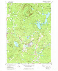
1981 Map of Mt. Pawtuckaway
USGS Topo · Published 1981About this map
The Pawtuckaway Mountains dominate the northern landscape of this Rockingham County survey, where South Mtn and Middle Mtn rise above the waters of Pawtuckaway Pond. This area is preserved as the Pawtuckaway State Park, featuring a Lookout Tower and a complex network of coves and islands such as Big Island and Horse Island. To the south, the settlement of Raymond serves as a local hub along the Lamprey River, marked by the path of the Boston and Maine Railroad. The map reveals a transition from these wooded highlands to the river-fed valleys, with several small family cemeteries like Bartlett Cem and Chase Cem scattered through the hills. This era shows the developed recreation and transit corridor prior to modern suburban expansion, preserving features like Onway Lake and the Exeter River headwaters.
Find a feature on this map
74 named features on this map. Tap any name to fly to it.
Don’t see what you’re looking for? This feature index may not catch every label — zoom into the map to look around manually.
Map Details
Editions of this 1981 Mt. Pawtuckaway Map
3 editions found
Other maps of this area

1888 · Haverhill
USGS Topo · 1:62,500

1890 · Haverhill
USGS Topo · 1:62,500

1893 · Haverhill
USGS Topo · 1:62,500

1905 · Manchester
USGS Topo · 1:62,500

1917 · Mt. Pawtuckaway
USGS Topo · 1:62,500

1919 · Mt. Pawtuckaway
USGS Topo · 1:62,500

1921 · Suncook
USGS Topo · 1:62,500

1935 · Haverhill
USGS Topo · 1:62,500

1939 · Mt. Pawtuckaway
USGS Topo · 1:62,500

1941 · Manchester
USGS Topo · 1:62,500