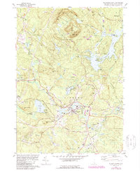
1981 Map of Mt. Pawtuckaway
USGS Topo · Published 1988About this map
The Pawtuckaway Mountains dominate the northern landscape of this Rockingham County region, where the town of Raymond serves as a primary hub for the surrounding settlements. This area is defined by its transition from the steep elevations of Mt Pawtuckaway and South Mtn to the low-lying glacial waters of Onway Lake and Governors Lake. The map reveals a land utilized for both recreation and industry, showing the expansion of Pawtuckaway State Park alongside numerous gravel pits and the Fairgrounds in Deerfield. For the genealogist, the sheet is exceptionally detailed, noting several family and community burial grounds including Bartlett Cem, Chase Cem, and Prescott Cem. The network of older routes like the Old Manchester Road and Critchett Road illustrates the historic connection between smaller locales like East Candia and Dumplingtown Hill.
Find a feature on this map
67 named features on this map. Tap any name to fly to it.
Don’t see what you’re looking for? This feature index may not catch every label — zoom into the map to look around manually.
Map Details
Editions of this 1981 Mt. Pawtuckaway Map
3 editions found
Other maps of this area

1888 · Haverhill
USGS Topo · 1:62,500

1890 · Haverhill
USGS Topo · 1:62,500

1893 · Haverhill
USGS Topo · 1:62,500

1905 · Manchester
USGS Topo · 1:62,500

1917 · Mt. Pawtuckaway
USGS Topo · 1:62,500

1919 · Mt. Pawtuckaway
USGS Topo · 1:62,500

1921 · Suncook
USGS Topo · 1:62,500

1935 · Haverhill
USGS Topo · 1:62,500

1939 · Mt. Pawtuckaway
USGS Topo · 1:62,500

1941 · Manchester
USGS Topo · 1:62,500