
1918 Map of Mt. Riley
USGS Topo · Published 1918About this map
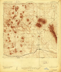
The United States Mexico international boundary defines the southern limit of this 1917 military-focused survey, where the prominent volcanic peak of Mt Riley rises above the Chihuahuan Desert. The landscape is dominated by the sprawling volcanic fields of the West Potrillo Mountains and the distinct ridgeline of the East Potrillo Mts. Transportation through this arid corridor relied heavily on the El Paso and Southwestern railroad, which arcs across the southern portion of the sheet near a marker labeled Monument. Remote ranching operations, such as Phillips Ranch and Cox Ranch, represent the sparse human footprint in this borderland, supported by essential water infrastructure like Cox Tank. The survey reflects a strategic wartime effort by the War Department to document the difficult terrain of Doña Ana County during a period of heightened border security.
Find a feature on this map
13 named features on this map. Tap any name to fly to it.
Don’t see what you’re looking for? This feature index may not catch every label — zoom into the map to look around manually.
Map Details
Editions of this 1918 Mt. Riley Map
2 editions found
Other maps of this area

1891 · Las Cruces
USGS Topo · 1:125,000

1893 · Las Cruces
USGS Topo · 1:125,000

1917 · Camel Mountain
USGS Topo · 1:62,500

1917 · Noria
USGS Topo · 1:62,500

1917 · Mt. Riley
USGS Topo · 1:62,500

1918 · Noria
USGS Topo · 1:62,500

1929 · Mt. Riley
USGS Topo · 1:62,500

1941 · Aden
USGS Topo · 1:62,500

1943 · Aden
USGS Topo · 1:62,500

1943 · Afton
USGS Topo · 1:62,500