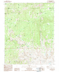
1988 Map of Mt. Silliman
USGS Topo · Published 1988About this map
Kings Canyon National Park and Sequoia National Park meet at the high ridges of the Silliman Divide in this late 1980s topographical study. The landscape is defined by its dramatic alpine geography, where the Silliman Crest forms a natural boundary between major drainage basins. High-altitude lakes including Seville Lake, Ranger Lake, and the isolated Silliman Lake are fed by snowmelt from peaks such as Mt Silliman and Kettle Peak.
Find a feature on this map
54 named features on this map. Tap any name to fly to it.
Don’t see what you’re looking for? This feature index may not catch every label — zoom into the map to look around manually.
Map Details
Editions of this 1988 Mt. Silliman Map
This is the sole edition of this map. No revisions or reprints were ever made.
Other maps of this area

1903 · Tehipite
USGS Topo · 1:125,000

1905 · Tehipite
USGS Topo · 1:125,000

1948 · Fresno
USGS Topo · 1:250,000

1952 · Tehipite Dome
USGS Topo · 1:62,500

1953 · Marion Peak
USGS Topo · 1:62,500

1955 · Fresno
USGS Topo · 1:250,000

1956 · Fresno
USGS Topo · 1:250,000

1956 · Giant Forest
USGS Topo · 1:62,500
1956 · Triple Divide Peak
USGS Topo · 1:62,500

1958 · Fresno
USGS Topo · 1:250,000