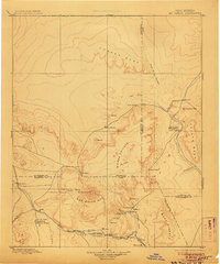
1899 Map of Mt. Taylor
USGS Topo · Published 1906About this map
Mt. Taylor anchors the high country of this late nineteenth-century reconnaissance, rising above a landscape of mesas and volcanic remnants. This region of northwest New Mexico shows the established rail corridor of the Santa Fe Pacific Railroad following the San Jose River, connecting vital early settlements like Grant and San Jose. Further north, the terrain transitions into the high sandstone plateaus of Chacra Mesa and Prieta Mesa, where smaller outposts like Cabezon and Guadalupe Casa Salazar sit along the winding Puerco River. The map highlights a diverse human geography ranging from the military history of Old Fort Wingate to the traditional mountain villages of San Mateo and Cebolleta. Geological features are prominent, specifically the massive Lava Field southwest of the peaks and the isolated volcanic plugs like Cabezon Peak.
Find a feature on this map
48 named features on this map. Tap any name to fly to it.
Don’t see what you’re looking for? This feature index may not catch every label — zoom into the map to look around manually.
Map Details
Editions of this 1899 Mt. Taylor Map
5 editions found

Other maps of this area

1883 · Mt. Taylor
USGS Topo · 1:250,000

1886 · Wingate
USGS Topo · 1:250,000

1886 · Mt. Taylor
USGS Topo · 1:250,000

1888 · Bernalillo
USGS Topo · 1:125,000

1889 · Albuquerque
USGS Topo · 1:125,000

1889 · Largo
USGS Topo · 1:250,000

1889 · Chaco
USGS Topo · 1:250,000

1890 · Jemes
USGS Topo · 1:125,000

1892 · Jemes
USGS Topo · 1:125,000

1892 · Wingate
USGS Topo · 1:250,000