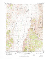
1961 Map of Mt. Tobin
USGS Topo · Published 1971About this map
Pleasant Valley and the Gold Banks Hills dominate this high-desert Nevada landscape, recorded during a 1961 field check. The map serves as a vital record for genealogists and mining historians, documenting former habitations like Goldbanks (Site) and Kennedy (Site). The concentration of resource extraction in the southern reaches is evident through the Tip Top Mine, Eureka Mine, and Camera Mine clustered near Miller Basin. In these arid basins, water remains the primary driver of human geography, marked by features such as the Goldbanks Windmill, Ringling Well, and the remote Pearce Sch. Further east, the terrain rises sharply toward Mt Tobin, overlooking deep drainages like Siard Canyon and the high passage at Golconda Pass. This survey preserves the exact locations of these remote outposts and infrastructure before many traces were lost to time.
Find a feature on this map
75 named features on this map. Tap any name to fly to it.
Don’t see what you’re looking for? This feature index may not catch every label — zoom into the map to look around manually.
Map Details
Editions of this 1961 Mt. Tobin Map
2 editions found
Other maps of this area

1932 · Sonoma Range
USGS Topo · 1:250,000

1939 · Sonoma Range
USGS Topo · 1:250,000

1955 · Winnemucca
USGS Topo · 1:250,000

1958 · Winnemucca
USGS Topo · 1:250,000
1961 · Kyle Hot Springs
USGS Topo · 1:62,500

1961 · Mt. Tobin
USGS Topo · 1:62,500

1961 · Cain Mountain
USGS Topo · 1:62,500

1961 · Leach Hot Springs
USGS Topo · 1:62,500

1961 · Fencemaker
USGS Topo · 1:62,500

1961 · Dun Glen
USGS Topo · 1:62,500