
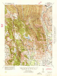
1942 Map of Mt. Vaca
USGS Topo · Published 1942About this map
The Vaca Mountains define the divide between Napa and Solano counties, where steep-sided canyons like Mix Canyon and Gates Canyon descend toward the fertile Vaca Valley. This 1940s tactical survey captures the transition from the high ridges of Mount Vaca and the Twin Sisters down to the valley floors, where rural life centered on Wooden Valley and Gordon Valley. In the lower elevations, the industrial and transport footprint of Fairfield and Tolenas is evident, anchored by the intersecting lines of the Southern Pacific and the Sacramento Northern railroads. Water management is a central theme of this landscape, with the Gordon Valley Dam creating Curry Lake, alongside several other reservoirs such as Lake Madigan and Suisun Reservoir that served the growing agricultural and municipal needs of the region during the early war years.
Find a feature on this map
45 named features on this map. Tap any name to fly to it.
Don’t see what you’re looking for? This feature index may not catch every label — zoom into the map to look around manually.
Map Details
Editions of this 1942 Mt. Vaca Map
2 editions found
Other maps of this area

1896 · Carquinez Strait
USGS Topo · 1:62,500

1898 · Karquines
USGS Topo · 1:62,500

1901 · Karquines
USGS Topo · 1:62,500

1902 · Napa
USGS Topo · 1:125,000

1907 · Woodland
USGS Topo · 1:62,500

1907 · Antioch
USGS Topo · 1:62,500

1908 · Vacaville
USGS Topo · 1:62,500

1908 · Antioch
USGS Topo · 1:62,500

1916 · Mare Island
USGS Topo · 1:62,500

1916 · Winters
USGS Topo · 1:31,680