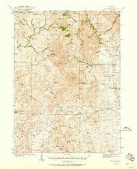
1935 Map of Mt. Velma
USGS Topo · Published 1958About this map
High-altitude ranching and mineral exploration define this Elko County landscape as it was surveyed in the mid-1930s. The terrain is a network of deep canyons and prominent peaks, including Cornwall Mtn and Mt Ichabod, where the headwaters of the Bruneau River and Beaver Creek begin their descent. A distinct pattern of family-owned ranching operations is scattered across the basins and gulches, with names such as Colvin Ranch, Goicoechea Ranch, and multiple sites belonging to the Prunty family.
Find a feature on this map
82 named features on this map. Tap any name to fly to it.
Don’t see what you’re looking for? This feature index may not catch every label — zoom into the map to look around manually.
Map Details
Editions of this 1935 Mt. Velma Map
5 editions found
Other maps of this area

1935 · Charleston
USGS Topo · 1:48,000

1936 · Mountain City
USGS Topo · 1:62,500

1936 · Rowland
USGS Topo · 1:48,000

1940 · Rowland
USGS Topo · 1:62,500

1940 · Mountain City
USGS Topo · 1:62,500

1942 · Mt. Velma
USGS Topo · 1:62,500

1943 · Jarbidge
USGS Topo · 1:62,500

1945 · Jarbidge
USGS Topo · 1:62,500

1955 · Wells
USGS Topo · 1:250,000

1956 · Wild Horse
USGS Topo · 1:62,500