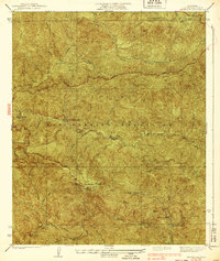
1939 Map of Mt. Wilson
USGS Topo · Published 1939About this map
Mt Wilson Observatory stands as the focal point of this 1930s topographic study, perched above a network of canyons and peaks within the Angeles National Forest. The map documents a significant era of recreational and administrative development in the San Gabriel Mountains, characterized by numerous wilderness camps and lodges. These early mountain retreats, including Opids Camp, Sturtevant Camp, and Valley Forge Lodge, were linked by rugged trails and the emerging Angeles Crest Highway, representing a period when the range was becoming increasingly accessible for scientific research and forest management.
Find a feature on this map
34 named features on this map. Tap any name to fly to it.
Don’t see what you’re looking for? This feature index may not catch every label — zoom into the map to look around manually.
Map Details
Editions of this 1939 Mt. Wilson Map
4 editions found
Other maps of this area

1894 · Los Angeles
USGS Topo · 1:62,500

1894 · Pomona
USGS Topo · 1:62,500

1896 · Pasadena
USGS Topo · 1:62,500

1897 · Pomona
USGS Topo · 1:62,500

1898 · Pomona
USGS Topo · 1:62,500

1900 · Pasadena
USGS Topo · 1:62,500

1900 · Tujunga
USGS Topo · 1:62,500

1900 · Los Angeles
USGS Topo · 1:62,500

1901 · Southern California Sheet No. 1
USGS Topo · 1:250,000

1903 · Rock Creek
USGS Topo · 1:62,500