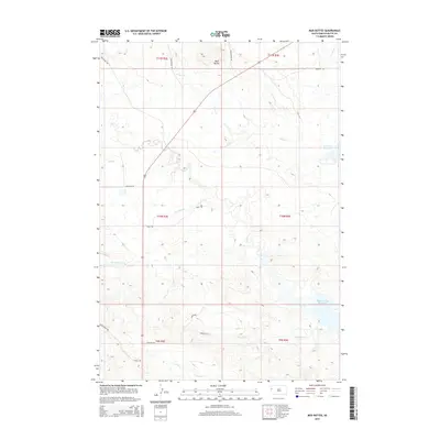
2015 Map of Mud Buttes
USGS Topo · Published 2015About this map
Mud Buttes rises as a prominent landmark in this arid portion of Butte County, where a complex network of seasonal drainages defines the West River landscape. The map showcases a transition from higher ground toward the northern reaches of the Belle Fourche Reservoir, an area shaped by livestock ranching and water management. Local transit is rooted in historic routes like Old Highway 85 and Camp Creek Rd, which provide access across a terrain carved by Owl Cr, Bitter Cr, and Roundout Cr. Smaller water features such as Guidinger Reservoir and Salt Cr highlight the critical importance of water resources in this ranching country. The absence of concentrated town sites emphasizes the open, agricultural character of the region during this 2015 survey, where section lines and rural roads like Kiplinger Rd and Wildcat Rd form the primary human footprint.
Find a feature on this map
27 named features on this map. Tap any name to fly to it.
Don’t see what you’re looking for? This feature index may not catch every label — zoom into the map to look around manually.
Map Details
Editions of this 2015 Mud Buttes Map
This is the sole edition of this map. No revisions or reprints were ever made.
Other maps of this area

1905 · Saint Onge
USGS Topo · 1:62,500

1905 · Indian
USGS Topo · 1:62,500

1906 · Two Top
USGS Topo · 1:62,500

1907 · Belle Fourche
USGS Topo · 1:125,000

1907 · Redwater
USGS Topo · 1:62,500

1953 · Rapid City
USGS Topo · 1:250,000
1954 · Belle Fourche
USGS Topo · 1:24,000
1954 · Fruitdale
USGS Topo · 1:24,000
1954 · Saint Onge
USGS Topo · 1:62,500

1957 · Rapid City
USGS Topo · 1:250,000