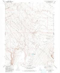
1972 Map of Mud Lake Reservoir
USGS Topo · Published 1993About this map
Snake Valley dominates this arid landscape, a broad basin where seasonal drainages like Toms Creek and Indian Farm Creek flow from higher elevations toward the valley floor. The hydrology of the region is further defined by the Mud Lake Reservoir and a significant Aqueduct, illustrating the infrastructure required to manage water in this high-desert environment. Historical transit routes cross the terrain, most notably the legendary Pony Express Road cutting across the northern reaches and the Weiss Highway providing a primary north-south artery through the valley. These roads reflect the enduring paths of travel and communication across the Great Basin. In the southern portion of the quadrangle, Red Cedar Creek descends from the foothills, contributing to the drainage network that feeds into the central basin.
Find a feature on this map
9 named features on this map. Tap any name to fly to it.
Don’t see what you’re looking for? This feature index may not catch every label — zoom into the map to look around manually.
Map Details
Editions of this 1972 Mud Lake Reservoir Map
2 editions found
Other maps of this area

1908 · Fish Springs
USGS Topo · 1:250,000

1910 · Fish Springs
USGS Topo · 1:250,000

1953 · Delta
USGS Topo · 1:250,000

1958 · Delta
USGS Topo · 1:250,000

1960 · Granite Mountain
USGS Topo · 1:62,500

1961 · Trout Creek
USGS Topo · 1:62,500

1962 · Delta
USGS Topo · 1:250,000

1972 · Mud Lake Reservoir
USGS Topo · 1:24,000
1972 · Boyd Station
USGS Topo · 1:24,000
1972 · Goshute Canyon
USGS Topo · 1:24,000