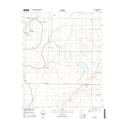
2014 Map of Mud Lake
USGS Topo · Published 2014About this map
The Saint Francis River and its intricate network of tributaries define this landscape on the border of St. Francis and Lee counties. In this alluvial region, drainage patterns are preserved through features like Blackfish Bayou, Fifteenmile Bayou, and Willbo Slough, which weave between small agricultural settlements. The map highlights a series of river-adjacent points including Council Bar and Walling Bar, as well as historical crossings such as Shepperd Crossing and Kingsley Crossing. Local history is anchored by the Locust Grove Cem and Bethlehem Cem, while the town of Bledsoe sits at a junction of roads near the county line. The hydrology of the area is further evidenced by named bends like Horseshoe Bend and the prominent Mud Lake itself, which provides a natural focal point for the southeastern portion of the quadrangle.
Find a feature on this map
63 named features on this map. Tap any name to fly to it.
Don’t see what you’re looking for? This feature index may not catch every label — zoom into the map to look around manually.
Map Details
Editions of this 2014 Mud Lake Map
This is the sole edition of this map. No revisions or reprints were ever made.
Other maps of this area

1931 · Horseshoe Lake
USGS Topo · 1:62,500

1939 · Horseshoe Lake
USGS Topo · 1:62,500

1939 · Park Place
USGS Topo · 1:62,500

1939 · Edmondson
USGS Topo · 1:62,500

1940 · Whitmore
USGS Topo · 1:62,500

1948 · Helena
USGS Topo · 1:250,000

1950 · Helena
USGS Topo · 1:250,000

1953 · Memphis
USGS Topo · 1:250,000

1954 · Horseshoe Lake
USGS Topo · 1:62,500

1954 · Edmondson
USGS Topo · 1:62,500