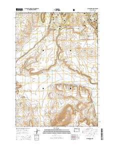
2014 Map of Mud Spring
USGS Topo · Published 2014About this map
The Ochoco National Forest spans this high-desert territory, characterized by its sharp rimrock and isolated buttes. The landscape is defined by drainage systems such as Beaver Creek and Wolf Creek, which cut through a series of dramatic landforms including Dahlgren Rim, Cordella Rim, and Salem Ridge. A single point of genealogical interest, the Beaver Creek Cem, sits near the center of the sheet, suggesting a long-standing human presence in this grazing and timber country.
Find a feature on this map
45 named features on this map. Tap any name to fly to it.
Don’t see what you’re looking for? This feature index may not catch every label — zoom into the map to look around manually.
Map Details
Editions of this 2014 Mud Spring Map
This is the sole edition of this map. No revisions or reprints were ever made.
Other maps of this area

1932 · Dayville
USGS Topo · 1:125,000

1936 · Dayville
USGS Topo · 1:125,000

1955 · Canyon City
USGS Topo · 1:250,000

1959 · Canyon City
USGS Topo · 1:250,000

1966 · Little Summit Prairie
USGS Topo · 1:24,000

1966 · Six Corners
USGS Topo · 1:24,000

1972 · Wolf Mountain
USGS Topo · 1:24,000
1981 · Powell Mtn
USGS Topo · 1:24,000

1981 · Suplee
USGS Topo · 1:24,000

1981 · Dayville
USGS Topo · 1:100,000