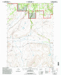
1992 Map of Mud Spring
USGS Topo · Published 1997About this map
Ochoco National Forest land and private ranch holdings define this high-desert landscape in central Oregon. The terrain is marked by significant rimrock features and volcanic buttes, including the prominent Laughlin Table and the steep drops of Cordella Rim. This era shows a landscape managed for water and cattle, with numerous family-named landmarks like Miller Ranch, Laughlin Ranch, and Lister Ranch established near essential water sources.
Find a feature on this map
44 named features on this map. Tap any name to fly to it.
Don’t see what you’re looking for? This feature index may not catch every label — zoom into the map to look around manually.
Map Details
Editions of this 1992 Mud Spring Map
This is the sole edition of this map. No revisions or reprints were ever made.
Other maps of this area

1932 · Dayville
USGS Topo · 1:125,000

1936 · Dayville
USGS Topo · 1:125,000

1955 · Canyon City
USGS Topo · 1:250,000

1959 · Canyon City
USGS Topo · 1:250,000

1966 · Little Summit Prairie
USGS Topo · 1:24,000

1966 · Six Corners
USGS Topo · 1:24,000

1972 · Wolf Mountain
USGS Topo · 1:24,000
1981 · Powell Mtn
USGS Topo · 1:24,000

1981 · Suplee
USGS Topo · 1:24,000

1981 · Dayville
USGS Topo · 1:100,000