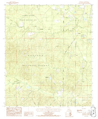
1985 Map of Mudville
USGS Topo · Published 1985About this map
The Kisatchie National Forest dominates this Central Louisiana landscape, where the dense timberlands are intersected by numerous watercourses and active resource extraction. Small settlements such as Selma, Lincecum, and Mudville are clustered along the northeastern edges, while Howcott sits further south near Sulphur Cr. The area is characterized by significant topographic variation, including Johns Hills and Breezy Hill, which stand above the winding drainages of Indian Creek and Fish Creek. Industrial activity is evident through a mapped Oil Field and Gravel Pit, signaling the region's reliance on natural resources. The Catahoula National Wildlife Management Area covers the northern portion of the quadrangle, illustrating the managed nature of these forests during the 1980s. Local researchers will find a complex network of forest roads and branches like Alligator Branch and Panther Bayou defining the rural layout.
Find a feature on this map
32 named features on this map. Tap any name to fly to it.
Don’t see what you’re looking for? This feature index may not catch every label — zoom into the map to look around manually.
Map Details
Editions of this 1985 Mudville Map
This is the sole edition of this map. No revisions or reprints were ever made.
Other maps of this area

1932 · Colfax NE
USGS Topo · 1:31,680

1932 · Colfax SE
USGS Topo · 1:31,680

1936 · Colfax
USGS Topo · 1:62,500

1936 · Pollock
USGS Topo · 1:62,500

1941 · Pollock
USGS Topo · 1:62,500

1950 · Winnfield
USGS Topo · 1:62,500

1951 · Winnfield
USGS Topo · 1:62,500

1953 · Alexandria
USGS Topo · 1:250,000

1954 · Tullos
USGS Topo · 1:62,500

1955 · Alexandria
USGS Topo · 1:250,000