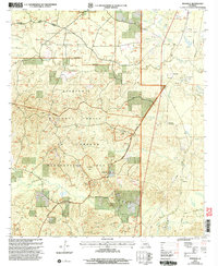
2003 Map of Mudville
USGS Topo · Published 2005About this map
Kisatchie National Forest dominates the western half of this 2003 revision, characterized by the rolling terrain of Johns Hills and a complex network of bayous and branches. The land management here is divided between forestry and military utility, evidenced by the large Penetration Area and Ground zones located south of the hills. To the north, the Catahoula National Wildlife Management Preserve protects the wetlands and timberlands near Kees Bayou and Alligator Branch. Settlement is concentrated along the eastern edge of the forest, where the small communities of Selma, Mudville, Lincecum, and Howcott are situated near Cypress Creek. The local economy in this part of Louisiana is clearly marked by extractive industry, with an Oil Field, numerous Drill Holes, and several Gravel Pits distributed across the landscape, particularly east of the Pipeline.
Find a feature on this map
38 named features on this map. Tap any name to fly to it.
Don’t see what you’re looking for? This feature index may not catch every label — zoom into the map to look around manually.
Map Details
Editions of this 2003 Mudville Map
This is the sole edition of this map. No revisions or reprints were ever made.
Other maps of this area

1932 · Colfax NE
USGS Topo · 1:31,680

1932 · Colfax SE
USGS Topo · 1:31,680

1936 · Colfax
USGS Topo · 1:62,500

1936 · Pollock
USGS Topo · 1:62,500

1941 · Pollock
USGS Topo · 1:62,500

1950 · Winnfield
USGS Topo · 1:62,500

1951 · Winnfield
USGS Topo · 1:62,500

1953 · Alexandria
USGS Topo · 1:250,000

1954 · Tullos
USGS Topo · 1:62,500

1955 · Alexandria
USGS Topo · 1:250,000