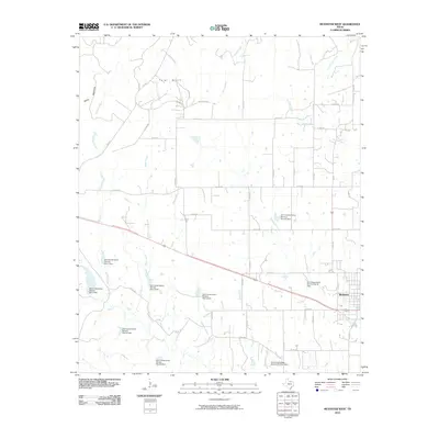
2010 Map of Muenster West
USGS Topo · Published 2010About this map
Muenster anchoring the southeastern corner, this landscape is defined by its extensive water management infrastructure and the rolling drainage basins of north central Texas. A dense network of federal flood control structures, such as Soil Conservation Service Site 6e Dam and Soil Conservation Service Site 19 Dam, protects the area where numerous waterways like Brushy Elm Creek and Waller Creek converge. To the northwest, the terrain rises toward the distinctive Tyler Bluff, flanked by landmarks with evocative names like Backbone and Devils. This 2010 survey illustrates the modern rural-urban interface, showing how the grid of county roads and highways like HWY 373 connects isolated farms and ranches to the primary settlement. The proliferation of Soil Conservation Service dams indicates a highly managed watershed designed to mitigate erosion and flooding across the Dry Elm Creek drainage system.
Find a feature on this map
55 named features on this map. Tap any name to fly to it.
Don’t see what you’re looking for? This feature index may not catch every label — zoom into the map to look around manually.
Map Details
Editions of this 2010 Muenster West Map
This is the sole edition of this map. No revisions or reprints were ever made.
Other maps of this area

1902 · Gainesville
USGS Topo · 1:125,000

1905 · Montague
USGS Topo · 1:125,000

1943 · Gainesville
USGS Topo · 1:125,000

1954 · Sherman
USGS Topo · 1:250,000

1958 · Sherman
USGS Topo · 1:250,000

1961 · Muenster West
USGS Topo · 1:24,000

1961 · Saint Jo
USGS Topo · 1:24,000

1961 · Freemound
USGS Topo · 1:24,000

1961 · Hood
USGS Topo · 1:24,000
1961 · Forestburg
USGS Topo · 1:24,000