
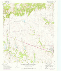
1961 Map of Muenster West
USGS Topo · Published 1963About this map
The borderlands of Montague and Cooke counties are defined here by a transition from the elevated Devil's Backbone and Tyler Bluff down into the fertile watersheds of the Fort Trinity River. During the early 1960s, the western edge of Muenster serves as the primary population center, with the Missouri Kansas Texas railroad cutting a direct diagonal path across the rolling prairie. This line was essential for the local agricultural economy, linking the ranching and farming operations of North Texas to wider markets.
Find a feature on this map
19 named features on this map. Tap any name to fly to it.
Don’t see what you’re looking for? This feature index may not catch every label — zoom into the map to look around manually.
Map Details
Editions of this 1961 Muenster West Map
2 editions found
Other maps of this area

1902 · Gainesville
USGS Topo · 1:125,000

1905 · Montague
USGS Topo · 1:125,000

1943 · Gainesville
USGS Topo · 1:125,000

1954 · Sherman
USGS Topo · 1:250,000

1958 · Sherman
USGS Topo · 1:250,000

1961 · Saint Jo
USGS Topo · 1:24,000

1961 · Freemound
USGS Topo · 1:24,000

1961 · Hood
USGS Topo · 1:24,000
1961 · Forestburg
USGS Topo · 1:24,000

1961 · Muenster East
USGS Topo · 1:24,000