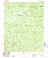
1987 Map of Muir Grove
USGS Topo · Published 1987About this map
The high Sierra Nevada landscape of Tulare County is captured here in the late 1980s, defined by the intersections of Sequoia National Forest, Kings Canyon National Park, and the Jennie Lakes Wilderness. This area represents a transition between managed timberlands and protected wilderness, centered on the ancient giants within Muir Grove and Little Boulder Grove. Human presence is concentrated around seasonal recreation hubs like Stony Creek Village and Big Meadows Station, which served as critical access points for those traversing the Kings Kaweah Divide.
Find a feature on this map
50 named features on this map. Tap any name to fly to it.
Don’t see what you’re looking for? This feature index may not catch every label — zoom into the map to look around manually.
Map Details
Editions of this 1987 Muir Grove Map
This is the sole edition of this map. No revisions or reprints were ever made.
Other maps of this area

1903 · Tehipite
USGS Topo · 1:125,000

1905 · Tehipite
USGS Topo · 1:125,000

1948 · Fresno
USGS Topo · 1:250,000

1952 · Tehipite Dome
USGS Topo · 1:62,500

1953 · Marion Peak
USGS Topo · 1:62,500

1955 · Fresno
USGS Topo · 1:250,000

1956 · Fresno
USGS Topo · 1:250,000

1956 · Giant Forest
USGS Topo · 1:62,500
1956 · Triple Divide Peak
USGS Topo · 1:62,500

1958 · Fresno
USGS Topo · 1:250,000