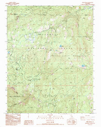
1993 Map of Muir Grove
USGS Topo · Published 1994About this map
Muir Grove and its ancient sequoia stands anchor the southern portion of this high-altitude landscape where Kings Canyon National Park meets the Sequoia National Forest. The map documents a critical intersection of protected wilderness and forest service infrastructure in the early 1990s, centered on the Generals Hwy corridor. This roadway serves as the lifeline for the area's recreational geography, connecting travelers to Stony Creek Village and several established backcountry access points like Big Meadows Campground and Dorst Campground.
Find a feature on this map
48 named features on this map. Tap any name to fly to it.
Don’t see what you’re looking for? This feature index may not catch every label — zoom into the map to look around manually.
Map Details
Editions of this 1993 Muir Grove Map
This is the sole edition of this map. No revisions or reprints were ever made.
Other maps of this area

1903 · Tehipite
USGS Topo · 1:125,000

1905 · Tehipite
USGS Topo · 1:125,000

1948 · Fresno
USGS Topo · 1:250,000

1952 · Tehipite Dome
USGS Topo · 1:62,500

1953 · Marion Peak
USGS Topo · 1:62,500

1955 · Fresno
USGS Topo · 1:250,000

1956 · Fresno
USGS Topo · 1:250,000

1956 · Giant Forest
USGS Topo · 1:62,500
1956 · Triple Divide Peak
USGS Topo · 1:62,500

1958 · Fresno
USGS Topo · 1:250,000