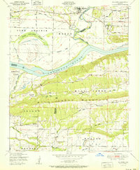
1951 Map of Mulberry
USGS Topo · Published 1951About this map
Mulberry serves as the focal point of this 1951 survey, situated along the Missouri Pacific railroad where the Mulberry River winds toward its confluence with the Arkansas River. The landscape is defined by the sharp transition from the river bottoms to the imposing Mill Creek Mountain, which separates the fertile plains of Vine Prairie from the southern drainages. This mid-century view documents a rural community supported by a mix of agriculture and industry, shown through several sawmills and a strip mine near the settlement of Vesta. Local history is deeply embedded in the map's labels, which locate numerous country churches and schools that anchored life in the early 1950s. Pleasant View and Riverdale appear as small settlements, while the presence of Court House Slough and Arbuckle Island illustrates the complex, shifting hydrology of the river system before modern navigation controls.
Find a feature on this map
41 named features on this map. Tap any name to fly to it.
Don’t see what you’re looking for? This feature index may not catch every label — zoom into the map to look around manually.
Map Details
Editions of this 1951 Mulberry Map
2 editions found
Other maps of this area

1879 · Cravens
USGS Topo · 1:62,500

1887 · Magazine Mountain #2
USGS Topo · 1:62,500

1887 · Watalula
USGS Topo · 1:62,500

1887 · Magazine Mountain
USGS Topo · 1:62,500

1890 · Magazine Mountain
USGS Topo · 1:125,000

1890 · Fort Smith
USGS Topo · 1:125,000

1898 · Winslow #4
USGS Topo · 1:62,500

1898 · Winslow
USGS Topo · 1:125,000

1901 · Winslow
USGS Topo · 1:125,000

1906 · Lavaca
USGS Topo · 1:62,500