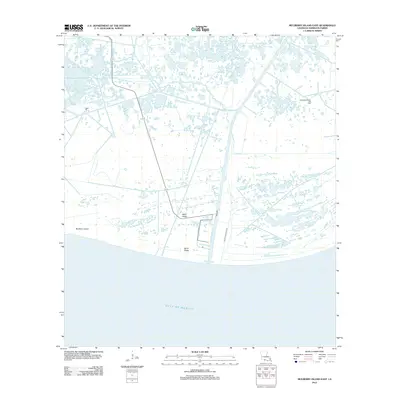
2012 Map of Mulberry Island East
USGS Topo · Published 2012About this map
Mulberry Island anchors this coastal portion of Vermilion Parish, where the marshy landscape meets the Gulf of Mexico. The area is defined by a complex network of wetlands and tidal channels, most notably Freshwater Bayou, which cuts through the terrain to support industrial and maritime access. Natural elevation is sparse, characterized by low-lying features such as Beef Ridge and Sand Ridge that rise slightly above the surrounding inundation.
Find a feature on this map
7 named features on this map. Tap any name to fly to it.
Don’t see what you’re looking for? This feature index may not catch every label — zoom into the map to look around manually.
Map Details
Editions of this 2012 Mulberry Island East Map
This is the sole edition of this map. No revisions or reprints were ever made.
Other maps of this area

1932 · Pecan Island SE
USGS Topo · 1:31,680

1932 · Pecan Island SW
USGS Topo · 1:31,680

1945 · Pecan Island NW
USGS Topo · 1:31,680

1945 · Pecan Island NE
USGS Topo · 1:31,680

1946 · Redfish Point SW
USGS Topo · 1:31,680

1946 · Redfish Point NW
USGS Topo · 1:31,680

1951 · Pecan Island
USGS Topo · 1:62,500

1951 · Cheniere Au Tigre
USGS Topo · 1:62,500
1954 · Redfish Point SW
USGS Topo · 1:31,680
1954 · Pecan Island SW
USGS Topo · 1:31,680