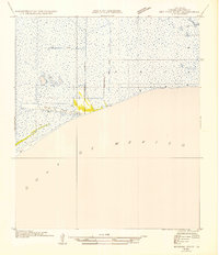
1954 Map of Redfish Point SW
USGS Topo · Published 1954About this map
Chenier Au Tigre stands as the primary outpost of human activity on this low-lying coastal stretch of Vermilion Parish. This 1954 advance sheet, based on field work from 1932 and aerial photography by the Air Corps, illustrates the precarious intersection of land and sea along the Gulf of Mexico. The presence of St Francis Ch indicates a established community presence on this coastal ridge, surrounded by vast marshes and an expansive Mud Flat. The landscape is defined by its hydraulic engineering, with the Cutoff Canal and other unnamed waterways cutting through the wetlands. Boundary lines such as East Line R 2 E and West Line R 3 E divide the marsh into administrative blocks, reflecting the systematic efforts of the Board of State Engineers to manage this fluid environment before mid-century changes altered the coastline.
Find a feature on this map
8 named features on this map. Tap any name to fly to it.
Don’t see what you’re looking for? This feature index may not catch every label — zoom into the map to look around manually.
Map Details
Editions of this 1954 Redfish Point SW Map
This is the sole edition of this map. No revisions or reprints were ever made.
Other maps of this area

1932 · Pecan Island SE
USGS Topo · 1:31,680

1945 · Pecan Island NE
USGS Topo · 1:31,680

1946 · Redfish Point SW
USGS Topo · 1:31,680

1946 · Redfish Point NE
USGS Topo · 1:31,680

1946 · Redfish Point SE
USGS Topo · 1:31,680

1946 · Redfish Point NW
USGS Topo · 1:31,680

1951 · Pecan Island
USGS Topo · 1:62,500

1951 · Cheniere Au Tigre
USGS Topo · 1:62,500
1954 · Redfish Point SE
USGS Topo · 1:31,680
1954 · Redfish Point NE
USGS Topo · 1:31,680