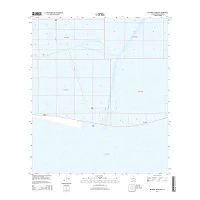
2015 Map of Mulberry Island East
USGS Topo · Published 2015About this map
Mulberry Island sits at the edge of the Gulf of Mexico, defining a landscape where the coastal marshes of Vermilion Parish meet the open sea. This 2015 survey reveals a terrain dominated by strategic ridges and artificial waterways, reflecting the region's managed coastal hydrology. Elevated ground follows a series of distinct landforms including Beef Ridge, Bill Ridge, Sand Ridge, and Front Ridge, which provide subtle relief amidst the surrounding wetlands. These ridges likely represent historical cheniers—relict beach ridges that serve as vital high ground in the deltaic plain. The primary north-south artery for both navigation and drainage is the Freshwater Bayou Canal, complemented by Freshwater Bayou and the east-west Dewitt Canal. Road access is limited to the winding path of La-3147, which navigates the interior between these watery boundaries.
Find a feature on this map
14 named features on this map. Tap any name to fly to it.
Don’t see what you’re looking for? This feature index may not catch every label — zoom into the map to look around manually.
Map Details
Editions of this 2015 Mulberry Island East Map
This is the sole edition of this map. No revisions or reprints were ever made.
Other maps of this area

1932 · Pecan Island SE
USGS Topo · 1:31,680

1932 · Pecan Island SW
USGS Topo · 1:31,680

1945 · Pecan Island NW
USGS Topo · 1:31,680

1945 · Pecan Island NE
USGS Topo · 1:31,680

1946 · Redfish Point SW
USGS Topo · 1:31,680

1946 · Redfish Point NW
USGS Topo · 1:31,680

1951 · Pecan Island
USGS Topo · 1:62,500

1951 · Cheniere Au Tigre
USGS Topo · 1:62,500
1954 · Redfish Point SW
USGS Topo · 1:31,680
1954 · Pecan Island SW
USGS Topo · 1:31,680