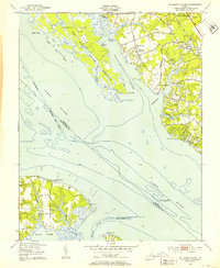
1950 Map of Mulberry Island
USGS Topo · Published 1953About this map
The Fort Eustis Military Reservation dominates the landscape of this 1950s coastal survey, illustrating the significant military footprint along the James River. The map captures a period of varied land use, from the expansive Prison Farm and Prison Barracks at Menchville to the quiet presence of the Mennonite Colony near the Warwick River Ch. Strategic transportation and infrastructure are evident in the path of the Chesapeake and Ohio railroad and the Patrick Henry Airport on the eastern edge.
Find a feature on this map
50 named features on this map. Tap any name to fly to it.
Don’t see what you’re looking for? This feature index may not catch every label — zoom into the map to look around manually.
Map Details
Editions of this 1950 Mulberry Island Map
This is the sole edition of this map. No revisions or reprints were ever made.
Other maps of this area

1907 · Norfolk
USGS Topo · 1:125,000

1907 · Yorktown
USGS Topo · 1:62,500

1907 · Hampton
USGS Topo · 1:62,500

1919 · Smithfield
USGS Topo · 1:62,500

1921 · Newport News
USGS Topo · 1:62,500

1943 · Yorktown
USGS Topo · 1:62,500

1943 · Richmond
USGS Topo · 1:250,000

1944 · Yorktown
USGS Topo · 1:24,000

1944 · Morrison
USGS Topo · 1:24,000

1944 · Harris Grove
USGS Topo · 1:24,000