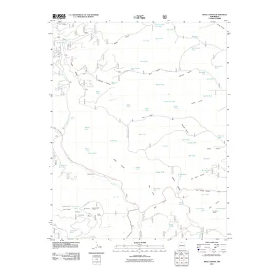
2011 Map of Mule Canyon
USGS Topo · Published 2011About this map
Tusas Ridge dominates this northern New Mexico landscape, a high-elevation divide where complex water management systems and mineral prospecting define the historical footprint. The high desert terrain is punctuated by numerous catchments such as Gurule Tank and Barela Number Two Tank, reflecting the essential nature of water storage in this arid region. Near the southern boundary, a concentrated area of mineral exploration is evident through features like the Virginia Mine and the Milwaukee Belle Prospect, indicating a period of significant geological interest in the vicinity of State Hwy 111. The presence of the Tusas Cemetery offers a poignant genealogical touchpoint, marking the human persistence in this high country. Cattle ranching and land use patterns are further illustrated by named features like Loco Ridge and Esquibel Canyon, while local history is preserved in landmarks like Roybal Spring and Biscara Spring.
Find a feature on this map
83 named features on this map. Tap any name to fly to it.
Don’t see what you’re looking for? This feature index may not catch every label — zoom into the map to look around manually.
Map Details
Editions of this 2011 Mule Canyon Map
This is the sole edition of this map. No revisions or reprints were ever made.
Other maps of this area

1918 · Tusas
USGS Topo · 1:125,000

1954 · Raton
USGS Topo · 1:250,000

1954 · Aztec
USGS Topo · 1:250,000

1958 · Raton
USGS Topo · 1:250,000

1958 · Aztec
USGS Topo · 1:250,000

1962 · Aztec
USGS Topo · 1:250,000
1963 · Las Tablas
USGS Topo · 1:24,000

1963 · Broke Off Mountain
USGS Topo · 1:24,000

1963 · Burned Mountain
USGS Topo · 1:24,000
1963 · La Segita Peaks
USGS Topo · 1:24,000