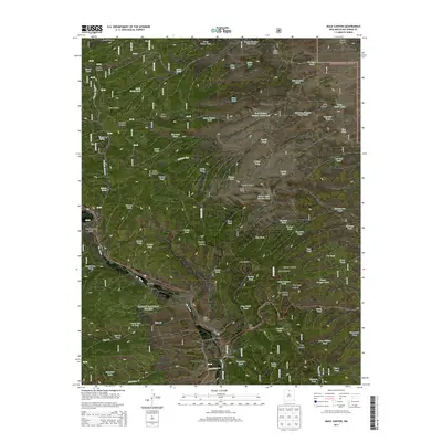
2013 Map of Mule Canyon
USGS Topo · Published 2013About this map
Carson National Forest land dominates this section of Rio Arriba County, where the high-altitude landscape is defined by an intricate network of drainage canyons and ridges. The presence of Tusas Cem near the Rio Tusas suggests the localized historical importance of small settlements or ranching communities that once utilized these remote valleys. The terrain is marked by numerous natural springs and man-made water catchments, such as Barela Spring and Bicara Tank, reflecting the critical need for water management in this arid grazing country. A complex series of named canyons, including Mule Canyon, Tres Piedras Canyon, and Guido Canyon, carve through the region, separated by prominent high points like Tusas Ridge and Loco Ridge. This drainage pattern illustrates the geological character of the north-central New Mexico uplands and the sparse, infrastructure-light footprint of the early 21st century.
Find a feature on this map
84 named features on this map. Tap any name to fly to it.
Don’t see what you’re looking for? This feature index may not catch every label — zoom into the map to look around manually.
Map Details
Editions of this 2013 Mule Canyon Map
This is the sole edition of this map. No revisions or reprints were ever made.
Other maps of this area

1918 · Tusas
USGS Topo · 1:125,000

1954 · Raton
USGS Topo · 1:250,000

1954 · Aztec
USGS Topo · 1:250,000

1958 · Raton
USGS Topo · 1:250,000

1958 · Aztec
USGS Topo · 1:250,000

1962 · Aztec
USGS Topo · 1:250,000
1963 · Las Tablas
USGS Topo · 1:24,000

1963 · Broke Off Mountain
USGS Topo · 1:24,000

1963 · Burned Mountain
USGS Topo · 1:24,000
1963 · La Segita Peaks
USGS Topo · 1:24,000