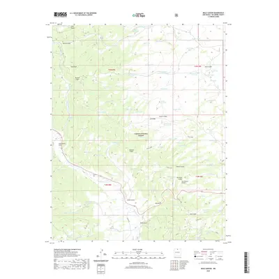
2020 Map of Mule Canyon
USGS Topo · Published 2020About this map
Carson National Forest terrain defines this portion of Rio Arriba County, where the high-altitude landscape is marked by a complex system of water management features and steep drainage canyons. The area is characterized by numerous stock tanks and springs, such as Barela Spring and Bivara Tank, which supported the local ranching economy. The historical footprint of human settlement is evidenced by the Tusas Cem and the winding route of the Tusas Loop, which navigates through the varied topography of Tusas Ridge and Loco Ridge. Deep canyons like Mule Canyon and Esquibel Canyon provide a clear view of the natural corridors used for movement through the timbered highlands. This survey documents the intersection of federal forest management and the enduring geography of Northern New Mexico's uplands.
Find a feature on this map
85 named features on this map. Tap any name to fly to it.
Don’t see what you’re looking for? This feature index may not catch every label — zoom into the map to look around manually.
Map Details
Editions of this 2020 Mule Canyon Map
This is the sole edition of this map. No revisions or reprints were ever made.
Other maps of this area

1918 · Tusas
USGS Topo · 1:125,000

1954 · Raton
USGS Topo · 1:250,000

1954 · Aztec
USGS Topo · 1:250,000

1958 · Raton
USGS Topo · 1:250,000

1958 · Aztec
USGS Topo · 1:250,000

1962 · Aztec
USGS Topo · 1:250,000
1963 · Las Tablas
USGS Topo · 1:24,000

1963 · Broke Off Mountain
USGS Topo · 1:24,000

1963 · Burned Mountain
USGS Topo · 1:24,000
1963 · La Segita Peaks
USGS Topo · 1:24,000