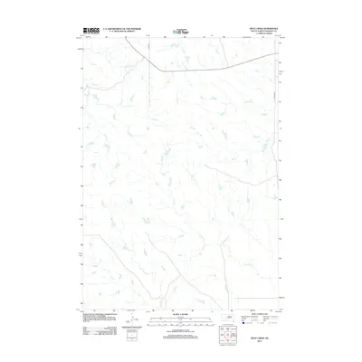
2012 Map of Mule Creek
USGS Topo · Published 2012About this map
Mule Cr and Plum Cr define the drainage patterns of this Haakon County landscape, reflecting the intricate network of watercourses that shape the regional geography. This section of South Dakota is characterized by a sparse road network, primarily featuring Quinn Rd and Ottumwa Rd, which facilitate travel through the vast prairie. The convergence of numerous named streams, including South Cr, Deer Cr, and Mitchell Cr, highlights a terrain where seasonal water flow is a primary geographic driver. The map captures a moment in the early 21st century before modern development significantly altered these rural ranchlands, providing a clear record of natural drainage features like Shanty Cr alongside established local thoroughfares.
Find a feature on this map
8 named features on this map. Tap any name to fly to it.
Don’t see what you’re looking for? This feature index may not catch every label — zoom into the map to look around manually.
Map Details
Editions of this 2012 Mule Creek Map
This is the sole edition of this map. No revisions or reprints were ever made.
Other maps of this area

1954 · Pierre
USGS Topo · 1:250,000

1958 · Pierre
USGS Topo · 1:250,000

1983 · Mule Creek
USGS Topo · 1:24,000

1983 · Philip
USGS Topo · 1:100,000

1983 · Moenville
USGS Topo · 1:24,000

1983 · Middle Draw
USGS Topo · 1:24,000

1983 · Powell NW
USGS Topo · 1:24,000

1983 · Tornado Ranch
USGS Topo · 1:24,000
1983 · Ottumwa
USGS Topo · 1:24,000
1983 · Lucerne
USGS Topo · 1:24,000