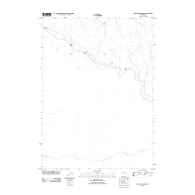
2011 Map of Muleshoe Creek
USGS Topo · Published 2011About this map
The Niobrara River carves through this northern Nebraska landscape, creating a complex corridor of islands and rapids. Features like Fritzs Island and The Chute illustrate the river's braided character, while Conners Rapid and Egelhoffs Rapid indicate the fast-moving water that has long shaped local navigation and recreation. Human presence is marked by isolated cattle operations including McKee Ranch, Owens Ranch, and Cramer Ranch, reflecting the region's enduring ranching economy.
Find a feature on this map
17 named features on this map. Tap any name to fly to it.
Don’t see what you’re looking for? This feature index may not catch every label — zoom into the map to look around manually.
Map Details
Editions of this 2011 Muleshoe Creek Map
This is the sole edition of this map. No revisions or reprints were ever made.
Other maps of this area

1950 · Norden
USGS Topo · 1:62,500

1950 · Sparks
USGS Topo · 1:62,500

1950 · Wood Lake
USGS Topo · 1:62,500

1950 · Arabia
USGS Topo · 1:62,500

1952 · Norden
USGS Topo · 1:62,500

1957 · Valentine
USGS Topo · 1:250,000

1959 · Valentine
USGS Topo · 1:250,000
1983 · Norden
USGS Topo · 1:24,000
1983 · Sparks
USGS Topo · 1:24,000
1983 · Muleshoe Creek
USGS Topo · 1:24,000