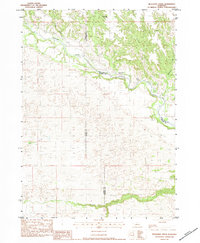
1983 Map of Muleshoe Creek
USGS Topo · Published 1984About this map
The Niobrara River winds through this northern Nebraska landscape, carving a deep valley through the borderlands of Cherry, Keya Paha, and Brown Counties. In the early 1980s, this area remained characterized by vast ranching tracts and limited river crossings, most notably at Rocky Ford. The map captures a transition in the terrain where the river valley gives way to the sandhills topography to the south, marked by the headwaters of Lost Creek and the drainage of Fairfield Creek. Scattered evidence of human activity is visible at the Owens Ranch and the Sunny Brook Camp, illustrating the isolated nature of these rural homesteads. Numerous tributaries, including Muleshoe Creek, Clapp Creek, and Colemon Creek, feed into the Niobrara, defining the watershed's complex erosional patterns.
Find a feature on this map
11 named features on this map. Tap any name to fly to it.
Don’t see what you’re looking for? This feature index may not catch every label — zoom into the map to look around manually.
Map Details
Editions of this 1983 Muleshoe Creek Map
2 editions found

Other maps of this area

1950 · Norden
USGS Topo · 1:62,500

1950 · Sparks
USGS Topo · 1:62,500

1950 · Wood Lake
USGS Topo · 1:62,500

1950 · Arabia
USGS Topo · 1:62,500

1952 · Norden
USGS Topo · 1:62,500

1957 · Valentine
USGS Topo · 1:250,000

1959 · Valentine
USGS Topo · 1:250,000
1983 · Norden
USGS Topo · 1:24,000
1983 · Sparks
USGS Topo · 1:24,000
1983 · Hayford Lake
USGS Topo · 1:24,000