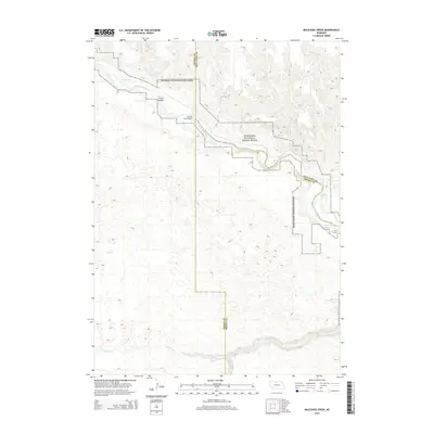
2014 Map of Muleshoe Creek
USGS Topo · Published 2014About this map
The Niobrara National Scenic River corridor dominates this landscape at the intersection of Cherry, Keya Paha, and Brown Counties. The map documents a stretch of river characterized by navigation hazards and small islands, including Conners Rapid, Egelhoffs Rapid, and the prominent Fritzs Island. Infrastructure is sparse in this protected area, with the County Line Bridge serving as a primary crossing point near The Chute. Tributaries like Muleshoe Cr and Coleman Cr feed the main river from the north, while the southern section of the quadrangle is defined by the winding course of Fairfield Cr and its S Fork Fairfield Cr. The terrain is marked by significant topographical shifts at Egelhoffs Narrows, where the river channel constricts between steep banks.
Find a feature on this map
17 named features on this map. Tap any name to fly to it.
Don’t see what you’re looking for? This feature index may not catch every label — zoom into the map to look around manually.
Map Details
Editions of this 2014 Muleshoe Creek Map
This is the sole edition of this map. No revisions or reprints were ever made.
Other maps of this area

1950 · Norden
USGS Topo · 1:62,500

1950 · Sparks
USGS Topo · 1:62,500

1950 · Wood Lake
USGS Topo · 1:62,500

1950 · Arabia
USGS Topo · 1:62,500

1952 · Norden
USGS Topo · 1:62,500

1957 · Valentine
USGS Topo · 1:250,000

1959 · Valentine
USGS Topo · 1:250,000
1983 · Norden
USGS Topo · 1:24,000
1983 · Sparks
USGS Topo · 1:24,000
1983 · Muleshoe Creek
USGS Topo · 1:24,000