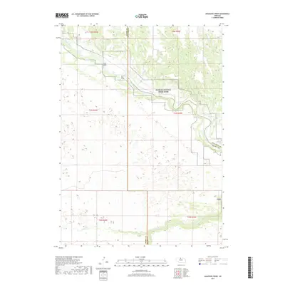
2017 Map of Muleshoe Creek
USGS Topo · Published 2017About this map
The Niobrara National Scenic River carves through the sandhills and canyon country of north-central Nebraska, defining a landscape of active waterways and shifting terrain. This area, located at the junction of Keya Paha, Cherry, and Brown counties, is marked by the river's dynamic flow over Conners Rapid and through the constriction of Egelhoffs Narrows. Notable landmarks include Fritzs Island and the County Line Bridge, which serves as a vital crossing point in this sparsely populated region. The map highlights the intricate drainage network of tributaries such as Muleshoe Cr and Fairfield Cr as they feed into the main river valley. The presence of The Chute and Egelhoffs Rapid reflects the river's historical importance for navigation and its character as a free-flowing water system protected for its natural values.
Find a feature on this map
16 named features on this map. Tap any name to fly to it.
Don’t see what you’re looking for? This feature index may not catch every label — zoom into the map to look around manually.
Map Details
Editions of this 2017 Muleshoe Creek Map
This is the sole edition of this map. No revisions or reprints were ever made.
Other maps of this area

1950 · Norden
USGS Topo · 1:62,500

1950 · Sparks
USGS Topo · 1:62,500

1950 · Wood Lake
USGS Topo · 1:62,500

1950 · Arabia
USGS Topo · 1:62,500

1952 · Norden
USGS Topo · 1:62,500

1957 · Valentine
USGS Topo · 1:250,000

1959 · Valentine
USGS Topo · 1:250,000
1983 · Norden
USGS Topo · 1:24,000
1983 · Sparks
USGS Topo · 1:24,000
1983 · Muleshoe Creek
USGS Topo · 1:24,000