1938 Map of Mulky Gap
USGS Topo · Published 1965About this map
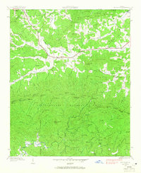
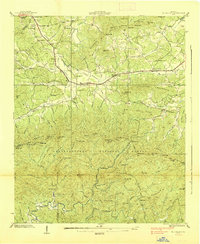
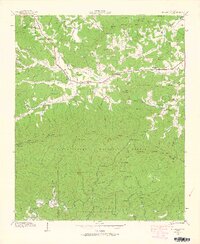
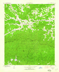
The Chattahoochee National Forest dominates the southern landscape of this Union and Fannin County survey, where the peaks of Duncan Ridge and Hicks Ridge create a sharp divide between drainages. The northern half of the map reveals a rural mountain society centered around post offices at Rugby and Youngcane. Evidence of New Deal era activity is prominent near the Cooper Creek corridor at C C C Camp No. F 12, while the Toccoa Forest Experiment Station and Clements Mtn Experiment Station indicate a landscape transitioned to scientific forest management. Small mountain congregations and local education are anchored at sites like Philadelphia Church and New Union School, with many family names preserved in the topography at Payne Knob and Harkins Cemetery.
Find a feature on this map
96 named features on this map. Tap any name to fly to it.
Don’t see what you’re looking for? This feature index may not catch every label — zoom into the map to look around manually.
Map Details
Editions of this 1938 Mulky Gap Map
4 editions found
Other maps of this area

1886 · Dahlonega
USGS Topo · 1:125,000

1888 · Ellijay
USGS Topo · 1:125,000

1892 · Dahlonega
USGS Topo · 1:125,000

1892 · Ellijay
USGS Topo · 1:125,000

1896 · Dahlonega
USGS Topo · 1:125,000

1898 · Ellijay
USGS Topo · 1:125,000

1903 · Dahlonega
USGS Topo · 1:125,000

1911 · Ellijay
USGS Topo · 1:125,000

1935 · Coosa Bald
USGS Topo · 1:24,000

1935 · Ivylog
USGS Topo · 1:24,000