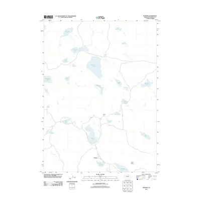
2011 Map of Mumper
USGS Topo · Published 2011About this map
Ashburger Lake and dozens of smaller water bodies dot this portion of the Nebraska Sandhills, defining a landscape shaped by shallow groundwater and wind-sculpted basins. In this remote ranching territory, the small settlement of Mumper serves as a primary reference point near the southern edge of the quadrangle. The area's agricultural identity is visible through the Four D Ranch and School Section Lake, the latter indicating land traditionally set aside for public education funding. Local navigation relies on a sparse network of section-line roads, including Road 181 and Road 110. A notable landmark for fire observation or orientation is Lookout Tower Number 1, situated on the higher ground of the dunes. The concentration of named lakes like North Cherry Lakes, Goose Lake, and the curiously named Tree Claim Lake highlights the importance of these water sources for both wildlife and the region's cattle industry.
Find a feature on this map
27 named features on this map. Tap any name to fly to it.
Don’t see what you’re looking for? This feature index may not catch every label — zoom into the map to look around manually.
Map Details
Editions of this 2011 Mumper Map
This is the sole edition of this map. No revisions or reprints were ever made.
Other maps of this area

1896 · Browns Creek
USGS Topo · 1:125,000

1899 · Browns Creek
USGS Topo · 1:125,000

1949 · Mumper
USGS Topo · 1:62,500

1950 · Crescent Lake
USGS Topo · 1:62,500

1950 · Storm Lake
USGS Topo · 1:62,500

1954 · Scottsbluff
USGS Topo · 1:250,000

1958 · Scottsbluff
USGS Topo · 1:250,000

1971 · Richardson Lake
USGS Topo · 1:24,000

1985 · Crescent Lake
USGS Topo · 1:100,000
1986 · Hessey Lake
USGS Topo · 1:24,000