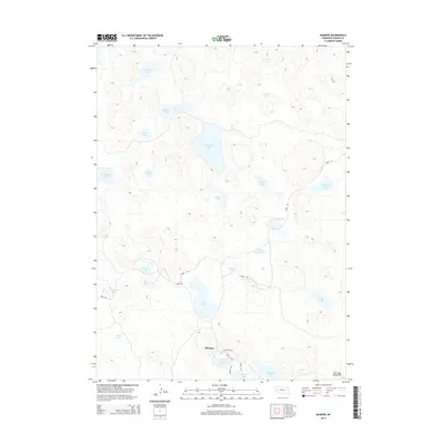
2014 Map of Mumper
USGS Topo · Published 2014About this map
Mumper serves as the primary focal point in this portion of the Nebraska Sandhills, a landscape defined by an extensive network of small lakes and seasonal ponds. The topography is characterized by rolling stabilized dunes, with distinctive elevations like Old Lady Beam Hill rising above the surrounding basin. Numerous water bodies, including Ashburger Lake, School Section Lake, and the cluster of Ramsay Lakes, dominate the terrain, illustrating the region's high water table and importance as a wetland habitat. Small local corridors such as Road 181 and Road 110 provide the only significant access through the hills, connecting isolated points like the Nature Trail near Gimlet Lake. The prevalence of named water features like Goose Lake and Rush Lake suggests a geography deeply tied to migratory patterns and local ranching history.
Find a feature on this map
29 named features on this map. Tap any name to fly to it.
Don’t see what you’re looking for? This feature index may not catch every label — zoom into the map to look around manually.
Map Details
Editions of this 2014 Mumper Map
This is the sole edition of this map. No revisions or reprints were ever made.
Other maps of this area

1896 · Browns Creek
USGS Topo · 1:125,000

1899 · Browns Creek
USGS Topo · 1:125,000

1949 · Mumper
USGS Topo · 1:62,500

1950 · Crescent Lake
USGS Topo · 1:62,500

1950 · Storm Lake
USGS Topo · 1:62,500

1954 · Scottsbluff
USGS Topo · 1:250,000

1958 · Scottsbluff
USGS Topo · 1:250,000

1971 · Richardson Lake
USGS Topo · 1:24,000

1985 · Crescent Lake
USGS Topo · 1:100,000
1986 · Hessey Lake
USGS Topo · 1:24,000