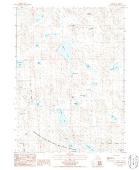
1986 Map of Mumper
USGS Topo · Published 1986About this map
Crescent Lake National Wildlife Refuge dominates this section of the Nebraska Sandhills, where a high density of semi-permanent lakes and ponds pocket the landscape. The intricate network of wetlands includes Ashburger Lake, North Cherry Lakes, and the uniquely named School Section Lake. This mid-1980s data illustrates the specialized ranching and conservation character of Garden County, where the isolated Mumper settlement and the Four D Ranch represent the sparse human footprint. In the southeast, the terrain rises toward Old Lady Beam Hill, while the low-lying basins are filled with diverse water bodies such as Roundup Lake and Goose Lake. The presence of Tree Claim Lake suggests early attempts at timber cultivation in this naturally treeless prairie region, a detail of interest to environmental and local historians.
Find a feature on this map
31 named features on this map. Tap any name to fly to it.
Don’t see what you’re looking for? This feature index may not catch every label — zoom into the map to look around manually.
Map Details
Editions of this 1986 Mumper Map
This is the sole edition of this map. No revisions or reprints were ever made.
Other maps of this area

1896 · Browns Creek
USGS Topo · 1:125,000

1899 · Browns Creek
USGS Topo · 1:125,000

1949 · Mumper
USGS Topo · 1:62,500

1950 · Crescent Lake
USGS Topo · 1:62,500

1950 · Storm Lake
USGS Topo · 1:62,500

1954 · Scottsbluff
USGS Topo · 1:250,000

1958 · Scottsbluff
USGS Topo · 1:250,000

1971 · Richardson Lake
USGS Topo · 1:24,000

1985 · Crescent Lake
USGS Topo · 1:100,000
1986 · Hessey Lake
USGS Topo · 1:24,000