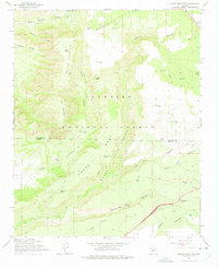
1965 Map of Munds Mountain
USGS Topo · Published 1975About this map
Munds Mountain dominates the high desert landscape south of Sedona in the mid-1960s, marking a transition between the elevated timberlands of the Coconino National Forest and the deep drainage of Beaver Creek. The map documents a complex network of ranching infrastructure, characterized by numerous water catchments like Munds Tank and Jacks Canyon Tank that supported livestock across the dry mesas. Human passage through this terrain is defined by historic routes like Schnebly Hill Road and the Jacks Canyon Trail, which navigate the steep descents from Schnebly Hill and Horse Mesa. Near the northern edge, Woods Ranch stands as a notable point of habitation, while landmarks like Robbers Roost and Merry-Go-Round suggest a landscape used for both utility and navigation. The crossing of the Coconino Co Yavapai Co line provides a clear boundary marker for local historians and land researchers.
Find a feature on this map
55 named features on this map. Tap any name to fly to it.
Don’t see what you’re looking for? This feature index may not catch every label — zoom into the map to look around manually.
Map Details
Editions of this 1965 Munds Mountain Map
3 editions found
Other maps of this area

1887 · Verde
USGS Topo · 1:250,000

1892 · Verde
USGS Topo · 1:250,000

1923 · Camp Verde
USGS Topo · 1:125,000

1932 · Camp Verde
USGS Topo · 1:125,000

1936 · Camp Verde
USGS Topo · 1:125,000

1954 · Holbrook
USGS Topo · 1:250,000

1957 · Holbrook
USGS Topo · 1:250,000

1958 · Holbrook
USGS Topo · 1:250,000

1960 · Holbrook
USGS Topo · 1:250,000
1965 · Munds Mountain
USGS Topo · 1:24,000