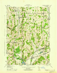
1944 Map of Munnsville
USGS Topo · Published 1944About this map
Oneida Creek carves a deep valley through the heart of Madison County, framing a landscape defined by mid-century agriculture and essential transport corridors. The New York Ontario and Western RR tracks follow the low ground through Munnsville and Solsville, while the Cherry Valley Turnpike cuts across the southern hills. This 1944 survey, completed by the Tennessee Valley Authority for the War Department, reveals a dense network of district schools such as School No 11 and School No 1, reflecting the rural social structure before modern consolidation.
Find a feature on this map
55 named features on this map. Tap any name to fly to it.
Don’t see what you’re looking for? This feature index may not catch every label — zoom into the map to look around manually.
Map Details
Editions of this 1944 Munnsville Map
This is the sole edition of this map. No revisions or reprints were ever made.
Other maps of this area

1895 · Oriskany
USGS Topo · 1:62,500

1895 · Oneida
USGS Topo · 1:62,500

1898 · Oneida
USGS Topo · 1:62,500

1898 · Oriskany
USGS Topo · 1:62,500

1902 · Morrisville
USGS Topo · 1:62,500

1902 · Oneida
USGS Topo · 1:62,500

1907 · Sangerfield
USGS Topo · 1:62,500

1939 · Oneida
USGS Topo · 1:62,500

1943 · West Eaton
USGS Topo · 1:24,000

1943 · Morrisville
USGS Topo · 1:24,000