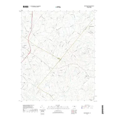
2019 Map of Murchisontown
USGS Topo · Published 2019About this map
Cameron and Murchisontown anchor this topographic study of the central North Carolina landscape, where the borders of Lee, Moore, and Harnett counties converge. The area is defined by a dense network of watercourses, including the many-branched Juniper Cr and Cypress Cr systems that feed into Gum Swamp and MacDonald Swamp. Prominent elevations like Big Ridge and Round Top rise above these drainage basins, while smaller landmarks such as Rooster Field and Blue Brothers Pond offer specific points of interest for local researchers. For those tracing family histories, the map identifies the Johnson Cem and Pierce Cem, situated along rural routes like Johnson Cemetary Rd and Blacks Chapel Rd. The infrastructure reflects a blend of historical transit paths like the Jefferson Davis Hwy and modern local access roads, illustrating how the terrain's ridges and valleys have dictated settlement and movement across three counties.
Find a feature on this map
133 named features on this map. Tap any name to fly to it.
Don’t see what you’re looking for? This feature index may not catch every label — zoom into the map to look around manually.
Map Details
Editions of this 2019 Murchisontown Map
This is the sole edition of this map. No revisions or reprints were ever made.
Other maps of this area

1948 · Southern Pines
USGS Topo · 1:62,500

1948 · Clifdale
USGS Topo · 1:62,500

1950 · Lobelia
USGS Topo · 1:24,000

1950 · Niagara
USGS Topo · 1:24,000

1951 · Clifdale
USGS Topo · 1:62,500

1953 · Raleigh
USGS Topo · 1:250,000

1954 · Raleigh
USGS Topo · 1:250,000

1957 · Murchisontown
USGS Topo · 1:24,000

1957 · Southern Pines
USGS Topo · 1:62,500
1957 · Niagara
USGS Topo · 1:24,000