
1957 Map of Murchisontown
USGS Topo · Published 1958About this map
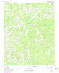
Murchisontown and the village of Cameron anchor this mid-century survey of the rural landscape where Moore, Lee, and Harnett Counties meet. The area is defined by a dense network of local congregations and burial grounds, such as McQueen Chapel, Macedonia Ch, and Garners Chapel, which speak to the deep-rooted community structure of the region. Transportation is dominated by the Seaboard Air Line and the Jefferson Davis Highway, cutting through terrain marked by prominent ridges like Greenwood and Big Ridge. In a notable intersection of history and geography, an Indian Mound is recorded south of Huckleberry Pond, positioned amidst the many branches and swamps that feed into the Little River. This map preserves the locations of local landmarks like the McIver Sch and various family-named sites such as Johnson Cem and Pierce Cem before modern development altered the rural landscape.
Find a feature on this map
69 named features on this map. Tap any name to fly to it.
Don’t see what you’re looking for? This feature index may not catch every label — zoom into the map to look around manually.
Map Details
Editions of this 1957 Murchisontown Map
2 editions found
Other maps of this area

1948 · Southern Pines
USGS Topo · 1:62,500

1948 · Clifdale
USGS Topo · 1:62,500

1950 · Lobelia
USGS Topo · 1:24,000

1950 · Niagara
USGS Topo · 1:24,000

1951 · Clifdale
USGS Topo · 1:62,500

1953 · Raleigh
USGS Topo · 1:250,000

1954 · Raleigh
USGS Topo · 1:250,000

1957 · Southern Pines
USGS Topo · 1:62,500
1957 · Niagara
USGS Topo · 1:24,000
1957 · Lobelia
USGS Topo · 1:24,000