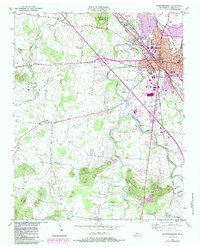
1950 Map of Murfreesboro
USGS Topo · Published 1984About this map
Stones River National Battlefield anchors the northern landscape of this mid-century survey, preserving the grounds of a pivotal Civil War conflict. The city of Murfreesboro radiates from its historic core at the Courthouse, showing significant expansion through the 1980s revision layer. This growth is evidenced by the development of the Fairgrounds and the industrial presence of the TVA Substation. Beyond the urban center, the map transitions into a rural network of family-named landmarks and essential community institutions like the County Farm and County Hospital.
Find a feature on this map
52 named features on this map. Tap any name to fly to it.
Don’t see what you’re looking for? This feature index may not catch every label — zoom into the map to look around manually.
Map Details
Editions of this 1950 Murfreesboro Map
5 editions found

Other maps of this area

1916 · Murfreesboro
USGS Topo · 1:62,500

1936 · Webbs Jungle
USGS Topo · 1:24,000

1936 · Rover
USGS Topo · 1:24,000

1936 · Fosterville
USGS Topo · 1:24,000

1942 · Lebanon
USGS Topo · 1:100,000

1944 · Shelbyville
USGS Topo · 1:100,000
1949 · Rover
USGS Topo · 1:24,000
1949 · Webbs Jungle
USGS Topo · 1:24,000
1949 · Fosterville
USGS Topo · 1:24,000

1950 · Walterhill
USGS Topo · 1:24,000
Featured Places
- Murfreesboro, TN
- Dixieland, TN
- Southern Aire, Murfreesboro
- Franklin Road Estates, Murfreesboro
- Ridgefield, Murfreesboro