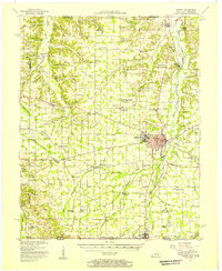
1951 Map of Murray
USGS Topo · Published 1957About this map
The town of Murray serves as the focal point of this 1950s survey, characterized by the campus of Murray State Teachers College and a growing infrastructure including a Sewage Disposal plant and Radio Tower (WNBS). The Nashville Chattanooga and St Louis railroad bisects the region, connecting smaller communities like Almo Heights and Hazel. The landscape is defined by the Tennessee Valley Divide, which separates the drainage of the West Fork Clarks River from the Little Mayfield Creek system.
Find a feature on this map
116 named features on this map. Tap any name to fly to it.
Don’t see what you’re looking for? This feature index may not catch every label — zoom into the map to look around manually.
Map Details
Editions of this 1951 Murray Map
This is the sole edition of this map. No revisions or reprints were ever made.
Other maps of this area

1936 · Conyersville
USGS Topo · 1:24,000

1936 · Farmington
USGS Topo · 1:24,000

1936 · Buchanan
USGS Topo · 1:24,000

1936 · Hazel
USGS Topo · 1:24,000

1936 · New Concord
USGS Topo · 1:24,000

1936 · Crossland
USGS Topo · 1:24,000

1936 · Oak Level
USGS Topo · 1:24,000

1936 · Lynn Grove
USGS Topo · 1:24,000

1936 · Hardin
USGS Topo · 1:24,000

1936 · Hiatt
USGS Topo · 1:24,000